06_06_08
Cycling Colorado
744 miles
My Location: Burlington, CO

|
Advertisements
Date: 07-02-08
Location: Burlington, CO
6:00am-1:00pm Limon, CO- Burlington, CO (76 miles) elevation 4,167 ft.
Little hills every 2 1/2 miles made the 1,000 ft. descent between Limon and Burlington feel like an ascent. Despite a n. west to s. east storm front, the wind felt like a headwind the entire ride. Not much but grassland around here. I imagine that will be my view until St. Louis.
Date: 07-01-08
Location: Limon, CO
6:30am-1:30pm Denver, CO- Limon, CO (85 miles) elevation 5,365 ft.
An easy ride on a hot, sunny day. Looks like I'm already at the great plains, with flat fields and constant little hills to climb. I arrived an hour before fierce winds. My tent stakes were pulled out of the ground. Kansas winds actually begin in Limon, CO, perhaps that's why there aren't any large towns in Colorado east of Denver.
Date: 06-29-08
Location: Denver, CO
9:30am-1:30pm Castle Rock, CO- Denver, CO (45 miles) elevation 5,280 ft.
Denver has an impressive downtown area, with a canal that you can ride or walk beside, surrounded by expensive condos. Nearby is a huge park with rides, etc., the Rockies stadium, Bronco's stadium, skyscrapers, and an arts center. The rest of Denver looks like its been neglected for 30 years. So I like 1% of Denver.
I think people in Colorado ride bikes & excercise more than anywhere else. Although, a quick check on the internet has Vermont 1st, Colorado 28th, but, another study has Colorado 1st. The prior study includes statistics like low teen birth rate which has nothing to do with fitness. My point is, Coloradians are fit.
 Denver city hall. Denver city hall.
|
 Denver downtown canal Denver downtown canal
|
 Denver canal ends in a little park Denver canal ends in a little park
|
Date: 06-27-08
Location: Castle Rock, CO
7:00am-1:30pm Colorado Springs, CO- Castle Rock, CO (52 miles) elevation 6,200 ft.
An easy ride despite being a little uphill and against the wind. The rest stop 11 miles south of Castle Rock wasn't needed, but was enjoyed. I could've ridden 30 more miles to Denver, but it takes all day to go into and out of most large cities.
At the Quality Inn Hotel, around 5:30pm the owner of the hotel entered my room, while I was naked, to make sure I was happy with the hotel. Very strange.
 Castle Rock school with the castle in background Castle Rock school with the castle in background
|
 Renaissance festival near Castle Rock Renaissance festival near Castle Rock
|
Date: 06-26-08
Location: Colorado Springs, CO
10:00am-3:00pm Canon City, CO- Colorado Springs, CO (55 miles) elevation 6,000 ft.
The terrain between Canon City and Colorado Springs is dry and rocky. The ride seemed more difficult than usual, perhaps I need a day of rest.
Colorado Springs beautiful downtown has small, trendy shops, nice restaurants, and a park in the center. Old, well-kept houses along tree shaded streets add to the quaint downtown feel.
I didn't ride my bike up Pike's Peak. I've been there before and couldn't think of a good reason to return. I did visit the Air Force Academy, but wasn't impressed enough to take pictures. I guess its just an academy, no rides, performances, or attractions. A 4 mile uphill ride with little payoff. I'm sure the Space & Air Museum in D.C. will be more impressive.
Date: 06-25-08
Location: Royal Gorge, CO
9:00am-2:00pm Monarch Mtn., CO- Royal Gorge, CO (74 miles) elevation 6,600 ft.
A leisurely 62 miles from Monarch Mtn. to Royal Gorge. Followed the Arkansas River through 40 miles of valley meadows, then a 22 mile canyon. When Hwy. 50 veered frrom the river, that's when a short 5 mile uphill climb started.
The Royal Gorge Bridge has been Disneyfied. Not being a national park, Canon City has turned this attraction into a theme park, and they did a pretty good job. The world's longest aerial tram, the world's highest sky coaster, and the world's steepest incline railway, along with the world's highest suspension bridge. They have 21 rides, shows, and attractions, including my favorite a singing animatronic dog.
Going across the bridge is still eerie. Wooden planks creeking with every step. You can feel the bridge shift when cars pass by. And if you look down, you can see the river between the planks and feel your imminent death. Leaning against the railing to take a picture, my camera was rocking as the bridge swayed in the wind.
 The Royal Gorge Bridge The Royal Gorge Bridge
|
 View from Royal Gorge bridge View from Royal Gorge bridge
|
 Through the bridge planks Through the bridge planks
|
 The Royal Gorge singing animatronic dog The Royal Gorge singing animatronic dog
|
Date: 06-24-08
Location: Salida, CO
7:30am-2:30pm Gunnison, CO- 18 west of Salida, CO (49 miles) elevation 7,000 ft. Monarch Pass (altitude 11,312) .
An easy 35 mile ride from Gunnison to Monarch Mtn. The 7 miles up Monarch Pass was manageable as long as I had elecrolites. Having run out of Cytomax, I used Gatorade and it worked well enough.
Monarch Pass is considered the Continental Divide, and has arrows pointing towards the Atlantic and Pacific, but I couldn't see tthe Atlantic from that vantage point because the Appalachian Mtns. were in the way.
On the way down Monarch Pass, I realized that I should've taken a picture. Oh well. Five miles down the mountain, I pulled over to put on rain gear and saw Monarch Mountain Lodge. Just in time to avoid a hail storm.
Date: 06-23-08
Location: Gunnison, CO
8:30am-10:30am Blue Mesa Reservoir, CO- Gunnison, CO (26 miles) elevation 7,700 ft.
Easy ride along 20 miles of Blue Mesa Reservoir all the way into Gunnison. The morning was sunny, but it started to rain just as I'm getting into the KOA Kampground.
Date: 06-22-08
Location: Blue Mesa Reservoir, CO
8:00am-5:00pm Ouray, CO - Blue Mesa Reservoir, CO (72 miles) elevation 6,500 ft. Two mtn. passes 8,000 ft. & 8,700 ft., climbing 2,500 ft. for both.
The 30 miles from Ouray to Montrose took 1:45 hours, the 40 miles from Montrose to Blue Mesa took 6 hours. High wind and two 2,500 ft. Climbs, along with rain slowed me down.
Plenty of sun going up Cerro Summit (8,042 ft.), but it rained when I reached Blue Mesa Summit (8,704 ft.). My cold weather clothes were packed in my rear saddle bag ( I normally keep them handy), so with only my light jacket, I peddled until I could find someplace to get out of the rain. Unfortunately, there was no respite. I think there's a beautiful canyon just after Blue Mesa Summit, its hard to tell when you're exhausted, freezing, riding downhill on wet pavement, with no shoulder, and cars passing by.
When going up Cerro Summit, a trucker (who looked like Nicholas Cage) stopped and hooked me up with brewer's yeast; high in potassium, vitamins & minerals. He said that it also helps rebuild ligaments, which I need since I've been riding with a pulled achilles tendon since Kingman, AZ. He adds the brewer's yeast to Gatorade which is mostly sugar and a little sodium. The brewer's yeast tastes horrible, but if I can find the right mix of sweetener and yeast perhaps its worth a try.
Date: 06-18-08
Location: Ouray, CO
8:00am-11:00am Silverton, CO - Ouray, CO (28 miles) elevation 7,700 ft. Red Mtn. Pass (11,018 ft)
The ride was pretty easy. Already starting at 9,200 ft., and a gradual climb of 5 miles to the base of Red Mountain made the 4 mile ascent up to 11,018 easy. It was downhill the rest of the 12 miles into Ouray to about 7,700 ft.
Ouray is a neat little historic tourist town. Cleaner than Silverton, but not Disney clean like Durango.
 Ouray Colorado Ouray Colorado
|
Date: 06-17-08
Location: Silverton, CO
7:30am-12:30pm Haviland Lake, CO - Silverton, CO (39 miles) elevation 9,200 ft. Coal Bank Pass (10,600 ft)
The ride up Coal Bank Pass was easier than expected because the ascent started only 10 miles from Haviland Lake, and my early morning climb provided tree shade up the mountain. The ascent lasted 6 miles and resulted in a quick 1 mile descent before the next hill. It was this 2nd hill that exhausted me. Already tired, no shade, the wind against me, and the dismay of seeing another mountain that lasted 5 miles, drained me of energy. Fortunately, I knew this was the last mountain before Silverton. The last 8 miles into Silverton were very easy. I hit the local grocery store and headed for a campground 2 miles north, only to find out it's a dry campground (bring your own water). So, I went back to Silverton where a motel manager/fellow cyclist gave me a AAA discount (I don't have AAA).
Silverton is smaller than I expected. Durango's oldtown is very Disney, yet authentic. Silverton is like an upscale shanti town, which is probably more authentic considering its an old mining town. The main street is nice, but the surrounding houses look like 19th century miners still live in them.
 Me at 10k ft. Me at 10k ft.
|
 View at Coal Bank Pass View at Coal Bank Pass
|
 Silverton, CO Silverton, CO
|
Date: 06-15-08
Location: Haviland Lake, CO
7:30am-11:30am Durango, CO - Haviland Lake, San Juan National Park, CO (29 miles) elevation 8,200 ft.
I'm glad I decided to skip Santa Fe, NM and instead ride the Rockies. This is absolutely beautiful country. I don't mind the hills or altitude and it's better than riding through a windy desert. The valley just north of Durango is beautiful, and I caught it on a non-windy day. I only rode 29 miles and felt like I could go another 20 easy. When I saw the Haviland Lake campground, I couldn't resist a relaxing dip in frigid water. I didn't think the water would be so cold.
I bought a tent, sleeping bag, and hammock at Walmart. Everything at Walmart is cheap, and that includes quality. If their tent has a 20 degree rating, it means 50 degrees. So I bought another sleeping bag/blanket to add warmth. The added weight is only 10 pounds, but the bulk looks like I'm pulling a fifth wheeler. Resting on the hammock is now a necessity.
 Haviland Lake with beaver dam in foreground. Haviland Lake with beaver dam in foreground.
|
Date: 06-13-08
Location: Durango, CO
9:00am-3:30pm Cortez, CO - Durango, CO (50 miles) elevation 6,500 ft.
Lots of hills and beautiful country. A quaint downtown with a steam train between Durango and Silverton.
Meeting a lot of cyclists lately. Race Across America (RAA) cyclists kept passing me on the way to Durango. I stopped and chatted with a Swiss cyclist with RAA. They tag-team across America in seven days. Also, Ride the Rockies (RTR) is starting in Durango this weekend.
Date: 06-12-08
Location: Mesa Verde National Park, CO
Cortez, CO - Mesa Verde National Park (64 miles roundtrip )
 Entering Mesa Verde National Park Entering Mesa Verde National Park
|
 Mesa Verde Cliff Palace Mesa Verde Cliff Palace
|
 Canyon surrounding the cliff dwellings Canyon surrounding the cliff dwellings
|
 View from the cliff dwellings View from the cliff dwellings
|
 Leaving Mesa Verde National Park Leaving Mesa Verde National Park
|
Date: 06-06-08
Location: Cortez, CO
5:30am-3:30pm Kayenta, AZ - Cortez, CO (121 miles)
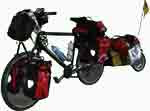
Would've been an easy ride if it weren't so long. Made good time despite a broken spoke causing rear wheel wobblage and the tire to rub against the break. My first experience at a KOA Kampground and I'm very impressed. It's like camping in your backyard, very neat, secure and
everyone is friendly. I'm a hit at the smores fest with my Heath pieces.
The Mesa Verde cliff dwellings is located near Cortez, and I'll visit the site when my bike is fixed. I'll be in Cortez from Fri 6/6/08-Fri 6/13/08.
Labels: Cycling Colorado
posted by Rick Anderson @ 6:14 PM
0 comments
![]()


